import json
import numpy as np
from bokeh.plotting import figure, show
from bokeh.models import GeoJSONDataSource, LinearColorMapper, ColorBar, HoverTool, FixedTicker, HoverTool
import cartopy.crs as ccrs
import cartopy.feature as cfeature
from shapely.geometry import shape, Point, Polygon, MultiPolygon
from shapely.ops import transform
import pyproj
import json
import requests
# Supported Projections!
projection = ccrs.Robinson(); projName = 'Robinson' # Robinson projection
# projection = ccrs.EckertIV() ; projName = 'EckertIV' # Eckert IV projection
# projection = ccrs.Sinusoidal(); projName = 'Sinusoidal' # Sinusoidal projection
# projection = ccrs.Miller() ; projName = 'Miller' # Miller projection
# projection = ccrs.AlbersEqualArea() ; projName = 'AlbersEqualArea' # AlbersEqualArea projection
# projection = ccrs.PlateCarree() ; projName = 'PlateCarree' # PlateCarree projection
# projection = ccrs.Orthographic(central_longitude = -80); projName = 'Orthographic' # Orthographic projection
# projection = ccrs.Mollweide() ; projName = 'Mollweide' # Mollweide projection
# projection = ccrs.EqualEarth(); projName = 'EqualEarth' # EqualEarth projection
def filter_valid_coordinates(coords):
"""
Filter out NaN coordinates and ensure valid coordinate pairs
"""
valid_coords = []
for coord in coords:
if len(coord) >= 2 and not (np.isnan(coord[0]) or np.isnan(coord[1]) or np.isinf(coord[0]) or np.isinf(coord[1])):
valid_coords.append([float(coord[0]), float(coord[1])])
return valid_coords
def transform_coordinates_cartopy(lon_lat_coords, target_crs=ccrs.EqualEarth()):
"""
Transform individual coordinate pairs using Cartopy
"""
source_crs = ccrs.PlateCarree()
# Convert to numpy arrays for vectorized operations
lons = np.array([coord[0] for coord in lon_lat_coords])
lats = np.array([coord[1] for coord in lon_lat_coords])
# Transform coordinates
transformed_coords = target_crs.transform_points(source_crs, lons, lats)
# Filter out NaN and infinite values
valid_coords = []
for x, y in zip(transformed_coords[:, 0], transformed_coords[:, 1]):
if not (np.isnan(x) or np.isnan(y) or np.isinf(x) or np.isinf(y)):
valid_coords.append([float(x), float(y)])
return valid_coords
def transform_geojson_simple(geojson_data, target_crs=ccrs.EqualEarth()):
"""
Simplified GeoJSON transformation using Cartopy
"""
transformed_data = json.loads(json.dumps(geojson_data))
features_to_remove = []
for i, feature in enumerate(transformed_data['features']):
geometry = feature['geometry']
feature_has_valid_coords = False
if geometry['type'] == 'Polygon':
new_coords = []
for ring_idx, ring in enumerate(geometry['coordinates']):
transformed_ring = transform_coordinates_cartopy(ring, target_crs)
if len(transformed_ring) >= 3: # Need at least 3 points for a valid polygon
new_coords.append(transformed_ring)
feature_has_valid_coords = True
if feature_has_valid_coords:
geometry['coordinates'] = new_coords
else:
features_to_remove.append(i)
elif geometry['type'] == 'MultiPolygon':
new_coords = []
for poly_idx, polygon in enumerate(geometry['coordinates']):
new_polygon = []
for ring_idx, ring in enumerate(polygon):
transformed_ring = transform_coordinates_cartopy(ring, target_crs)
if len(transformed_ring) >= 3:
new_polygon.append(transformed_ring)
feature_has_valid_coords = True
if new_polygon:
new_coords.append(new_polygon)
if feature_has_valid_coords:
geometry['coordinates'] = new_coords
else:
features_to_remove.append(i)
# Remove features with no valid coordinates
for i in reversed(features_to_remove):
del transformed_data['features'][i]
return transformed_data
# --- 1. Load world countries GeoJSON ---
url = "https://raw.githubusercontent.com/python-visualization/folium/master/examples/data/world-countries.json"
world_geo = requests.get(url).json()
# --- 2. Your population data ---
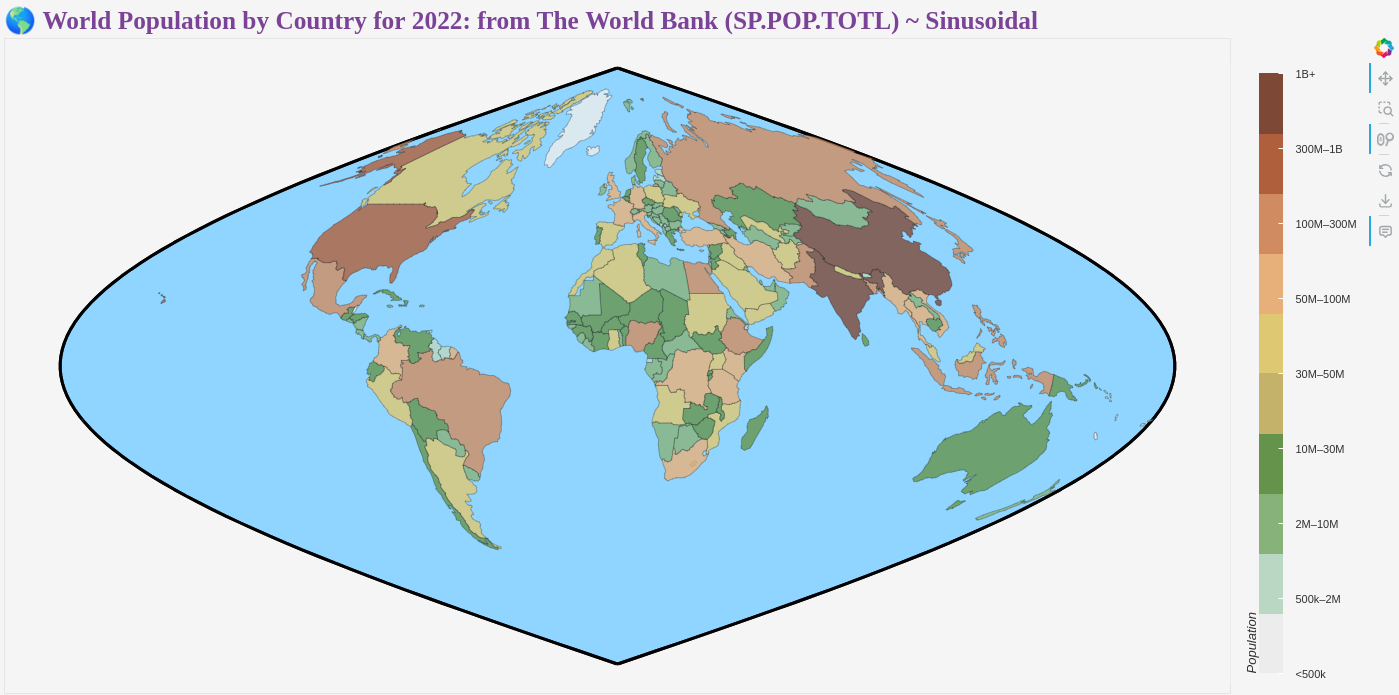
pop_data = [{"name": "Aruba", "value": 106445.0}, {"name": "Africa Eastern and Southern", "value": 720859132.0}, {"name": "Afghanistan", "value": 41128771.0}, {"name": "Africa Western and Central", "value": 490330870.0}, {"name": "Angola", "value": 35588987.0}, {"name": "Albania", "value": 2777689.0}, {"name": "Andorra", "value": 79824.0}, {"name": "Arab World", "value": 464684914.0}, {"name": "United Arab Emirates", "value": 9441129.0}, {"name": "Argentina", "value": 46234830.0}, {"name": "Armenia", "value": 2780469.0}, {"name": "American Samoa", "value": 44273.0}, {"name": "Antigua and Barbuda", "value": 93763.0}, {"name": "Australia", "value": 26005540.0}, {"name": "Austria", "value": 9041851.0}, {"name": "Azerbaijan", "value": 10141756.0}, {"name": "Burundi", "value": 12889576.0}, {"name": "Belgium", "value": 11685814.0}, {"name": "Benin", "value": 13352864.0}, {"name": "Burkina Faso", "value": 22673762.0}, {"name": "Bangladesh", "value": 171186372.0}, {"name": "Bulgaria", "value": 6465097.0}, {"name": "Bahrain", "value": 1472233.0}, {"name": "Bahamas, The", "value": 409984.0}, {"name": "Bosnia and Herzegovina", "value": 3233526.0}, {"name": "Belarus", "value": 9228071.0}, {"name": "Belize", "value": 405272.0}, {"name": "Bermuda", "value": 63532.0}, {"name": "Bolivia", "value": 12224110.0}, {"name": "Brazil", "value": 215313498.0}, {"name": "Barbados", "value": 281635.0}, {"name": "Brunei Darussalam", "value": 449002.0}, {"name": "Bhutan", "value": 782455.0}, {"name": "Botswana", "value": 2630296.0}, {"name": "Central African Republic", "value": 5579144.0}, {"name": "Canada", "value": 38929902.0}, {"name": "Central Europe and the Baltics", "value": 100108221.0}, {"name": "Switzerland", "value": 8775760.0}, {"name": "Channel Islands", "value": 174079.0}, {"name": "Chile", "value": 19603733.0}, {"name": "China", "value": 1412175000.0}, {"name": "Ivory Coast", "value": 28160542.0}, {"name": "Cameroon", "value": 27914536.0}, {"name": "Dem. Rep. Congo", "value": 99010212.0}, {"name": "Congo", "value": 5970424.0}, {"name": "Colombia", "value": 51874024.0}, {"name": "Comoros", "value": 836774.0}, {"name": "Cabo Verde", "value": 593149.0}, {"name": "Costa Rica", "value": 5180829.0}, {"name": "Caribbean small states", "value": 7505478.0}, {"name": "Cuba", "value": 11212191.0}, {"name": "Curacao", "value": 149996.0}, {"name": "Cayman Islands", "value": 68706.0}, {"name": "Cyprus", "value": 1251488.0}, {"name": "Czech Rep.", "value": 10672118.0}, {"name": "Germany", "value": 83797985.0}, {"name": "Djibouti", "value": 1120849.0}, {"name": "Dominica", "value": 72737.0}, {"name": "Denmark", "value": 5903037.0}, {"name": "Dominican Rep.", "value": 11228821.0}, {"name": "Algeria", "value": 44903225.0}, {"name": "East Asia & Pacific (excluding high income)", "value": 2129112126.0}, {"name": "Early-demographic dividend", "value": 3447398652.0}, {"name": "East Asia & Pacific", "value": 2375162207.0}, {"name": "Europe & Central Asia (excluding high income)", "value": 397824705.0}, {"name": "Europe & Central Asia", "value": 920375568.0}, {"name": "Ecuador", "value": 18001000.0}, {"name": "Egypt", "value": 110990103.0}, {"name": "Euro area", "value": 344475911.0}, {"name": "Eritrea", "value": 3684032.0}, {"name": "Spain", "value": 47778340.0}, {"name": "Estonia", "value": 1348840.0}, {"name": "Ethiopia", "value": 123379924.0}, {"name": "European Union", "value": 447370510.0}, {"name": "Fragile and conflict affected situations", "value": 1019139254.0}, {"name": "Finland", "value": 5556106.0}, {"name": "Fiji", "value": 929766.0}, {"name": "France", "value": 67971311.0}, {"name": "Faroe Islands", "value": 53090.0}, {"name": "Micronesia, Fed. Sts.", "value": 114164.0}, {"name": "Gabon", "value": 2388992.0}, {"name": "United Kingdom", "value": 66971395.0}, {"name": "Georgia", "value": 3712502.0}, {"name": "Ghana", "value": 33475870.0}, {"name": "Gibraltar", "value": 32649.0}, {"name": "Guinea", "value": 13859341.0}, {"name": "Gambia", "value": 2705992.0}, {"name": "Guinea Bissau", "value": 2105566.0}, {"name": "Equatorial Guinea", "value": 1674908.0}, {"name": "Greece", "value": 10426919.0}, {"name": "Grenada", "value": 125438.0}, {"name": "Greenland", "value": 56661.0}, {"name": "Guatemala", "value": 17357886.0}, {"name": "Guam", "value": 171774.0}, {"name": "Guyana", "value": 808726.0}, {"name": "High income", "value": 1244364814.0}, {"name": "Hong Kong SAR, China", "value": 7346100.0}, {"name": "Honduras", "value": 10432860.0}, {"name": "Heavily indebted poor countries (HIPC)", "value": 884288332.0}, {"name": "Croatia", "value": 3855600.0}, {"name": "Haiti", "value": 11584996.0}, {"name": "Hungary", "value": 9643048.0}, {"name": "IBRD only", "value": 4913887020.0}, {"name": "IDA & IBRD total", "value": 6754029970.0}, {"name": "IDA total", "value": 1840142950.0}, {"name": "IDA blend", "value": 607735968.0}, {"name": "Indonesia", "value": 275501339.0}, {"name": "IDA only", "value": 1232406982.0}, {"name": "Isle of Man", "value": 84519.0}, {"name": "India", "value": 1417173173.0}, {"name": "Ireland", "value": 5127170.0}, {"name": "Iran", "value": 88550570.0}, {"name": "Iraq", "value": 44496122.0}, {"name": "Iceland", "value": 382003.0}, {"name": "Israel", "value": 9557500.0}, {"name": "Italy", "value": 58940425.0}, {"name": "Jamaica", "value": 2827377.0}, {"name": "Jordan", "value": 11285869.0}, {"name": "Japan", "value": 125124989.0}, {"name": "Kazakhstan", "value": 19621972.0}, {"name": "Kenya", "value": 54027487.0}, {"name": "Kyrgyzstan", "value": 6974900.0}, {"name": "Cambodia", "value": 16767842.0}, {"name": "Kiribati", "value": 131232.0}, {"name": "St. Kitts and Nevis", "value": 47657.0}, {"name": "Korea", "value": 51628117.0}, {"name": "Kuwait", "value": 4268873.0}, {"name": "Latin America & Caribbean (excluding high income)", "value": 596596955.0}, {"name": "Laos", "value": 7529475.0}, {"name": "Lebanon", "value": 5489739.0}, {"name": "Liberia", "value": 5302681.0}, {"name": "Libya", "value": 6812341.0}, {"name": "St. Lucia", "value": 179857.0}, {"name": "Latin America & Caribbean", "value": 659310564.0}, {"name": "Least developed countries: UN classification", "value": 1125179454.0}, {"name": "Low income", "value": 703727949.0}, {"name": "Liechtenstein", "value": 39327.0}, {"name": "Sri Lanka", "value": 22181000.0}, {"name": "Lower middle income", "value": 3190184199.0}, {"name": "Low & middle income", "value": 6678280291.0}, {"name": "Lesotho", "value": 2305825.0}, {"name": "Late-demographic dividend", "value": 2325542891.0}, {"name": "Lithuania", "value": 2831639.0}, {"name": "Luxembourg", "value": 653103.0}, {"name": "Latvia", "value": 1879383.0}, {"name": "Macao SAR, China", "value": 695168.0}, {"name": "St. Martin (French part)", "value": 31791.0}, {"name": "Morocco", "value": 37457971.0}, {"name": "Monaco", "value": 36469.0}, {"name": "Moldova", "value": 2538894.0}, {"name": "Madagascar", "value": 29611714.0}, {"name": "Maldives", "value": 523787.0}, {"name": "Middle East & North Africa", "value": 493279469.0}, {"name": "Mexico", "value": 127504125.0}, {"name": "Marshall Islands", "value": 41569.0}, {"name": "Middle income", "value": 5974552342.0}, {"name": "Macedonia", "value": 2057679.0}, {"name": "Mali", "value": 22593590.0}, {"name": "Malta", "value": 531113.0}, {"name": "Myanmar", "value": 54179306.0}, {"name": "Middle East & North Africa (excluding high income)", "value": 424328381.0}, {"name": "Montenegro", "value": 617213.0}, {"name": "Mongolia", "value": 3398366.0}, {"name": "Northern Mariana Islands", "value": 49551.0}, {"name": "Mozambique", "value": 32969518.0}, {"name": "Mauritania", "value": 4736139.0}, {"name": "Mauritius", "value": 1262523.0}, {"name": "Malawi", "value": 20405317.0}, {"name": "Malaysia", "value": 33938221.0}, {"name": "North America", "value": 372280991.0}, {"name": "Namibia", "value": 2567012.0}, {"name": "New Caledonia", "value": 269220.0}, {"name": "Niger", "value": 26207977.0}, {"name": "Nigeria", "value": 218541212.0}, {"name": "Nicaragua", "value": 6948392.0}, {"name": "Netherlands", "value": 17700982.0}, {"name": "Norway", "value": 5457127.0}, {"name": "Nepal", "value": 30547580.0}, {"name": "Nauru", "value": 12668.0}, {"name": "New Zealand", "value": 5124100.0}, {"name": "OECD members", "value": 1376606817.0}, {"name": "Oman", "value": 4576298.0}, {"name": "Other small states", "value": 33169026.0}, {"name": "Pakistan", "value": 235824862.0}, {"name": "Panama", "value": 4408581.0}, {"name": "Peru", "value": 34049588.0}, {"name": "Philippines", "value": 115559009.0}, {"name": "Palau", "value": 18055.0}, {"name": "Papua New Guinea", "value": 10142619.0}, {"name": "Poland", "value": 36821749.0}, {"name": "Pre-demographic dividend", "value": 1038012552.0}, {"name": "Puerto Rico", "value": 3221789.0}, {"name": "Dem. Rep. Korea", "value": 26069416.0}, {"name": "Portugal", "value": 10409704.0}, {"name": "Paraguay", "value": 6780744.0}, {"name": "West Bank and Gaza", "value": 5043612.0}, {"name": "Pacific island small states", "value": 2639019.0}, {"name": "Post-demographic dividend", "value": 1113495082.0}, {"name": "French Polynesia", "value": 306279.0}, {"name": "Qatar", "value": 2695122.0}, {"name": "Romania", "value": 19047009.0}, {"name": "Russia", "value": 144236933.0}, {"name": "Rwanda", "value": 13776698.0}, {"name": "South Asia", "value": 1919348000.0}, {"name": "Saudi Arabia", "value": 36408820.0}, {"name": "Sudan", "value": 46874204.0}, {"name": "Senegal", "value": 17316449.0}, {"name": "Singapore", "value": 5637022.0}, {"name": "Solomon Islands", "value": 724273.0}, {"name": "Sierra Leone", "value": 8605718.0}, {"name": "El Salvador", "value": 6336392.0}, {"name": "San Marino", "value": 33660.0}, {"name": "Somalia", "value": 17597511.0}, {"name": "Republic of Serbia", "value": 6664449.0}, {"name": "Sub-Saharan Africa (excluding high income)", "value": 1211070124.0}, {"name": "South Sudan", "value": 10913164.0}, {"name": "Sub-Saharan Africa", "value": 1211190002.0}, {"name": "Small states", "value": 43313523.0}, {"name": "Sao Tome and Principe", "value": 227380.0}, {"name": "Suriname", "value": 618040.0}, {"name": "Slovakia", "value": 5431752.0}, {"name": "Slovenia", "value": 2111986.0}, {"name": "Sweden", "value": 10486941.0}, {"name": "Eswatini", "value": 1201670.0}, {"name": "Sint Maarten (Dutch part)", "value": 42848.0}, {"name": "Seychelles", "value": 119878.0}, {"name": "Syria", "value": 22125249.0}, {"name": "Turks and Caicos Islands", "value": 45703.0}, {"name": "Chad", "value": 17723315.0}, {"name": "East Asia & Pacific (IDA & IBRD countries)", "value": 2103055378.0}, {"name": "Europe & Central Asia (IDA & IBRD countries)", "value": 457549063.0}, {"name": "Togo", "value": 8848699.0}, {"name": "Thailand", "value": 71697030.0}, {"name": "Tajikistan", "value": 9952787.0}, {"name": "Turkmenistan", "value": 6430770.0}, {"name": "Latin America & the Caribbean (IDA & IBRD countries)", "value": 643602758.0}, {"name": "Timor-Leste", "value": 1341296.0}, {"name": "Middle East & North Africa (IDA & IBRD countries)", "value": 419284769.0}, {"name": "Tonga", "value": 106858.0}, {"name": "South Asia (IDA & IBRD)", "value": 1919348000.0}, {"name": "Sub-Saharan Africa (IDA & IBRD countries)", "value": 1211190002.0}, {"name": "Trinidad and Tobago", "value": 1531044.0}, {"name": "Tunisia", "value": 12356117.0}, {"name": "Turkey", "value": 84979913.0}, {"name": "Tuvalu", "value": 11312.0}, {"name": "United Republic of Tanzania", "value": 65497748.0}, {"name": "Uganda", "value": 47249585.0}, {"name": "Ukraine", "value": 38000000.0}, {"name": "Upper middle income", "value": 2784368143.0}, {"name": "Uruguay", "value": 3422794.0}, {"name": "United States", "value": 333287557.0}, {"name": "Uzbekistan", "value": 35648100.0}, {"name": "St. Vincent and the Grenadines", "value": 103948.0}, {"name": "Venezuela", "value": 28301696.0}, {"name": "British Virgin Islands", "value": 31305.0}, {"name": "Virgin Islands (U.S.)", "value": 105413.0}, {"name": "Vietnam", "value": 98186856.0}, {"name": "Vanuatu", "value": 326740.0}, {"name": "World", "value": 7950946801.0}, {"name": "Samoa", "value": 222382.0}, {"name": "Kosovo", "value": 1761985.0}, {"name": "Yemen", "value": 33696614.0}, {"name": "South Africa", "value": 59893885.0}, {"name": "Zambia", "value": 20017675.0}, {"name": "Zimbabwe", "value": 16320537.0}]
# --- 3. Convert to dictionary for fast lookup ---
pop_dict = {item['name']: item['value'] for item in pop_data}
# --- 4. Assign population data to each country in GeoJSON ---
for feature in world_geo['features']:
country = feature['properties']['name']
value = pop_dict.get(country, None)
# Country name fallbacks
if value is None:
if country == 'United States of America': value = pop_dict.get('United States')
elif country == 'Russian Federation': value = pop_dict.get('Russia')
elif country == 'Czech Republic': value = pop_dict.get('Czech Rep.')
elif country == "Democratic Republic of the Congo": value = pop_dict.get("Dem. Rep. Congo")
elif country == "Republic of the Congo": value = pop_dict.get("Congo")
elif country == "Korea, Republic of": value = pop_dict.get("Korea")
elif country == "Egypt, Arab Rep.": value = pop_dict.get("Egypt")
# ... add more custom matches if needed
feature['properties']['population'] = value
# (Optional) Remove countries with no data
world_geo['features'] = [f for f in world_geo['features'] if f['properties']['population'] is not None]
world_geo_projected = transform_geojson_simple(world_geo, projection)
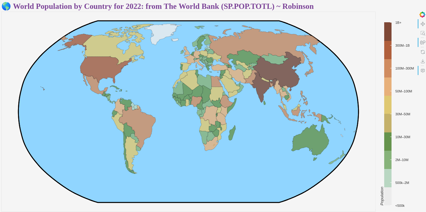
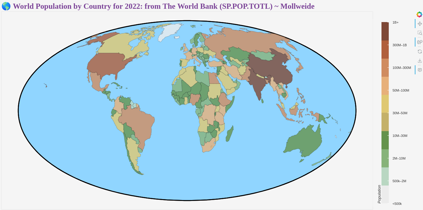
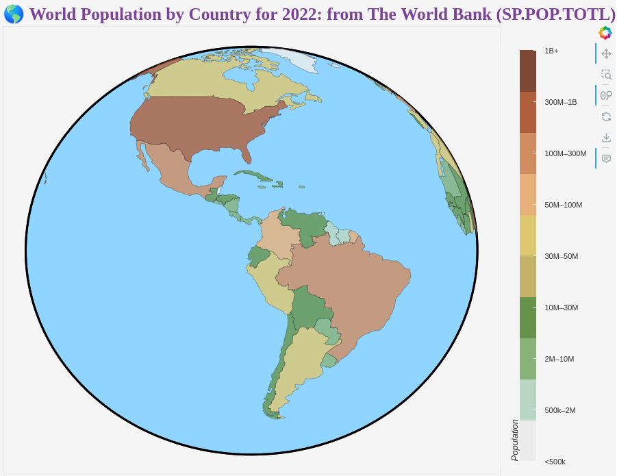
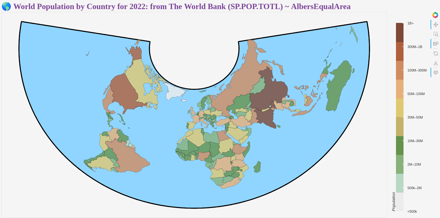
# --- 5. BINNING: Discrete Population Bins & Labels (logarithmic) ---
bin_edges = [0, 5e5, 2e6, 1e7, 3e7, 5e7, 1e8, 3e8, 1e9, 2e9]
bin_labels = [
"<500k", "500k–2M", "2M–10M", "10M–30M", "30M–50M",
"50M–100M", "100M–300M", "300M–1B", "1B+"
]
# Color palette
palette = [
"#ececec",
"#b9d7c2",
"#87b37a",
"#65934c",
"#c4b16a",
"#dfc872",
"#e7b07a",
"#d08c60",
"#b05f3c",
"#7e4836",
]
for feature in world_geo_projected['features']:
pop = feature['properties']['population']
# Assign a bin index
idx = next((i for i in range(len(bin_edges)-1)
if bin_edges[i] <= pop < bin_edges[i+1]), len(bin_labels)-1)
feature['properties']['pop_bin_index'] = idx
# --- 6. Bokeh data source ---
geosource = GeoJSONDataSource(geojson=json.dumps(world_geo_projected))
# --- 7. Discrete Palette & ColorMapper ---
color_mapper = LinearColorMapper(palette=palette, low=0, high=len(bin_labels)-1)
# --- 8. Create Earth boundary for visual reference ---
def create_earth_boundary(projection, n_points=360):
"""
Create a boundary outline of the Earth in the given projection
"""
source_crs = ccrs.PlateCarree()
boundary_points = []
boundary_points = []
# For orthographic and similar projections, create a circle
if isinstance(projection, (ccrs.Orthographic, ccrs.NearsidePerspective)):
# Create a circle boundary
angles = np.linspace(0, 2*np.pi, n_points)
radius = 6371000 # Earth radius in meters (approximate)
for angle in angles:
x = radius * np.cos(angle)
y = radius * np.sin(angle)
boundary_points.append([x, y])
# Close the circle
if boundary_points:
boundary_points.append(boundary_points[0])
return boundary_points
# Create a complete boundary by going around the globe edge
# Start from -180° longitude and go around
lons = np.linspace(-180, 180, n_points)
# Top edge (near north pole, but not exactly 90° to avoid singularities)
for lon in lons:
try:
transformed = projection.transform_point(lon, 89.9, source_crs)
if not (np.isnan(transformed[0]) or np.isnan(transformed[1])):
boundary_points.append([transformed[0], transformed[1]])
except:
continue
# Right edge (along 180° longitude)
lats = np.linspace(89.9, -89.9, n_points//4)
for lat in lats:
try:
transformed = projection.transform_point(179.9, lat, source_crs)
if not (np.isnan(transformed[0]) or np.isnan(transformed[1])):
boundary_points.append([transformed[0], transformed[1]])
except:
continue
# Bottom edge (near south pole)
for lon in reversed(lons):
try:
transformed = projection.transform_point(lon, -89.9, source_crs)
if not (np.isnan(transformed[0]) or np.isnan(transformed[1])):
boundary_points.append([transformed[0], transformed[1]])
except:
continue
# Left edge (along -180° longitude)
lats = np.linspace(-89.9, 89.9, n_points//4)
for lat in lats:
try:
transformed = projection.transform_point(-179.9, lat, source_crs)
if not (np.isnan(transformed[0]) or np.isnan(transformed[1])):
boundary_points.append([transformed[0], transformed[1]])
except:
continue
# Close the polygon
if boundary_points:
boundary_points.append(boundary_points[0])
return boundary_points
# Create Earth boundary
earth_boundary = create_earth_boundary(projection)
# --- 9. Build Bokeh plot ---
p = figure(
title=f"🌎 World Population by Country for 2022: from The World Bank (SP.POP.TOTL) ~ {projName}",
width=1400, # Optimized for Equal Earth aspect ratio
height=700,
toolbar_location='right',
tools='pan,box_zoom,reset,save,wheel_zoom',
active_scroll='wheel_zoom',
x_axis_location=None,
y_axis_location=None
)
if str(projection)[6:10] == 'orth':
p.width = 900
p.title=f"🌎 World Population by Country for 2022: from The World Bank (SP.POP.TOTL) ~ {projName}"
p.grid.grid_line_color = None
p.axis.visible = False
# Add Earth boundary outline first (so it appears behind countries)
if earth_boundary:
xs = [point[0] for point in earth_boundary]
ys = [point[1] for point in earth_boundary]
p.line(xs, ys,
line_color='black',
line_width=3,
alpha=0.8,
legend_label='Earth Boundary')
if earth_boundary:
xs = [point[0] for point in earth_boundary]
ys = [point[1] for point in earth_boundary]
p.patch(xs, ys, fill_color='#90D5FF', line_color='black', line_width=3, alpha=1.0, level='underlay')
countries = p.patches(
'xs', 'ys',
source=geosource,
fill_color={'field': 'pop_bin_index', 'transform': color_mapper},
line_color='black',
line_width=0.25,
fill_alpha=0.8,
hover_line_color='black',
hover_line_width=5,
)
# --- 10. Hover tool ---
hover = HoverTool(
renderers=[countries],
attachment="above",
show_arrow=False,
tooltips="""
<div style="background-color: #f0f0f0; padding: 5px; margin-bottom:30px; border-radius: 5px; box-shadow: 0px 0px 5px rgba(0,0,0,0.3);">
<font size="5" style="background-color: #f0f0f0; padding: 5px; border-radius: 5px;">
<i>Country:</i> <b>@name</b> <br>
<i>Population:</i> <b>@population{0,0}</b> <br>
</font>
</div>
<style>
:host {
--tooltip-border: transparent;
--tooltip-color: transparent;
--tooltip-text: #2f2f2f;
}
</style>
"""
)
p.add_tools(hover)
# --- 11. Discrete ColorBar ---
color_bar = ColorBar(
color_mapper=color_mapper,
ticker=FixedTicker(ticks=list(range(len(bin_labels)))),
major_label_overrides={i: l for i, l in enumerate(bin_labels)},
label_standoff=12,
width=24,
height=600,
border_line_color=None,
background_fill_color='#f5f5f5',
location=(0, 10),
orientation='vertical',
title='Population',
major_label_text_color="#2f2f2f",
title_text_color="#2f2f2f",
)
p.add_layout(color_bar, 'right')
# --- 12. Style ---
p.title.text_font_size = '19pt'
p.title.text_font = 'Montserrat'
p.title.text_color = '#7b4397'
p.background_fill_color = '#f5f5f5'
p.border_fill_color = '#f5f5f5'
p.legend.visible = False
show(p)
Please note that the currently supported projections are:
- Robinson
- EckertIV
- Sinusoidal
- Miller
- AlbersEqualArea
- PlateCarree
- Orthographic
- Mollweide
- EqualEarth